Pyrenees · Category 1 · Via Argelès-Gazost and Arrens-Marsous
Ride the Col du Soulor from Argelès-Gazost: 19.5 km at 5.2% to 1,474 m
On paper the Col du Soulor looks gentle: 19.5 km from Argelès-Gazost at an average of only 5.2%. In reality it is two climbs with a flat valley in between. A steep start out of town, ten easy kilometres through the villages of the Val d'Azun, and then the real Soulor: the last 7 km from Arrens-Marsous at about 8%, with no rest to the top. From the pass, the famous road along the cliffs of the Cirque du Litor leads on to the Col d'Aubisque.
Quick facts
- Distance
- 19.5 km
- Average grade
- 5.2%
- Max grade
- ~10%
- Elevation gain
- 1,019 m
- Summit
- 1,474 m
The experience
The Soulor (1,474 m) is in the Hautes-Pyrénées, between the Val d'Azun in the east and the Ouzom valley in the north-west. The road over it, the D918, is the old spa road between Argelès-Gazost and Laruns, and it carries on to the Col d'Aubisque about 10 km further west. From Argelès-Gazost, Wikipedia and climbbybike give 19.5 km at 5.2% with 1,019 m of climbing, and say it gets tough after Arrens-Marsous with stretches of 10% or more. From the north, from Arthez-d'Asson on the D126, it is 22 km at 4.9%, with the real climbing after Ferrières, where it reaches 9%.
Section by section from Argelès-Gazost, using the Altigraphs kilometre profile: the first three kilometres, through town and up to Arras-en-Lavedan, average 7.5–8.4% and have short ramps that are steeper still. Riders on climbbybike say the climb through Argelès itself is harder than expected. Then the road eases to 3–4% and, from kilometre 8 to 12, is almost flat through the villages of the Val d'Azun, with one short downhill. At Arrens-Marsous, at about 880 m, the real climb starts: 7.2 km and almost 600 m of climbing at an average of about 8.2%, with every kilometre between 7.6% and 9%. Climbfinder counts 6 hairpins on this part, and riders report signs at each kilometre showing the distance to the top and the gradient of the next kilometre.
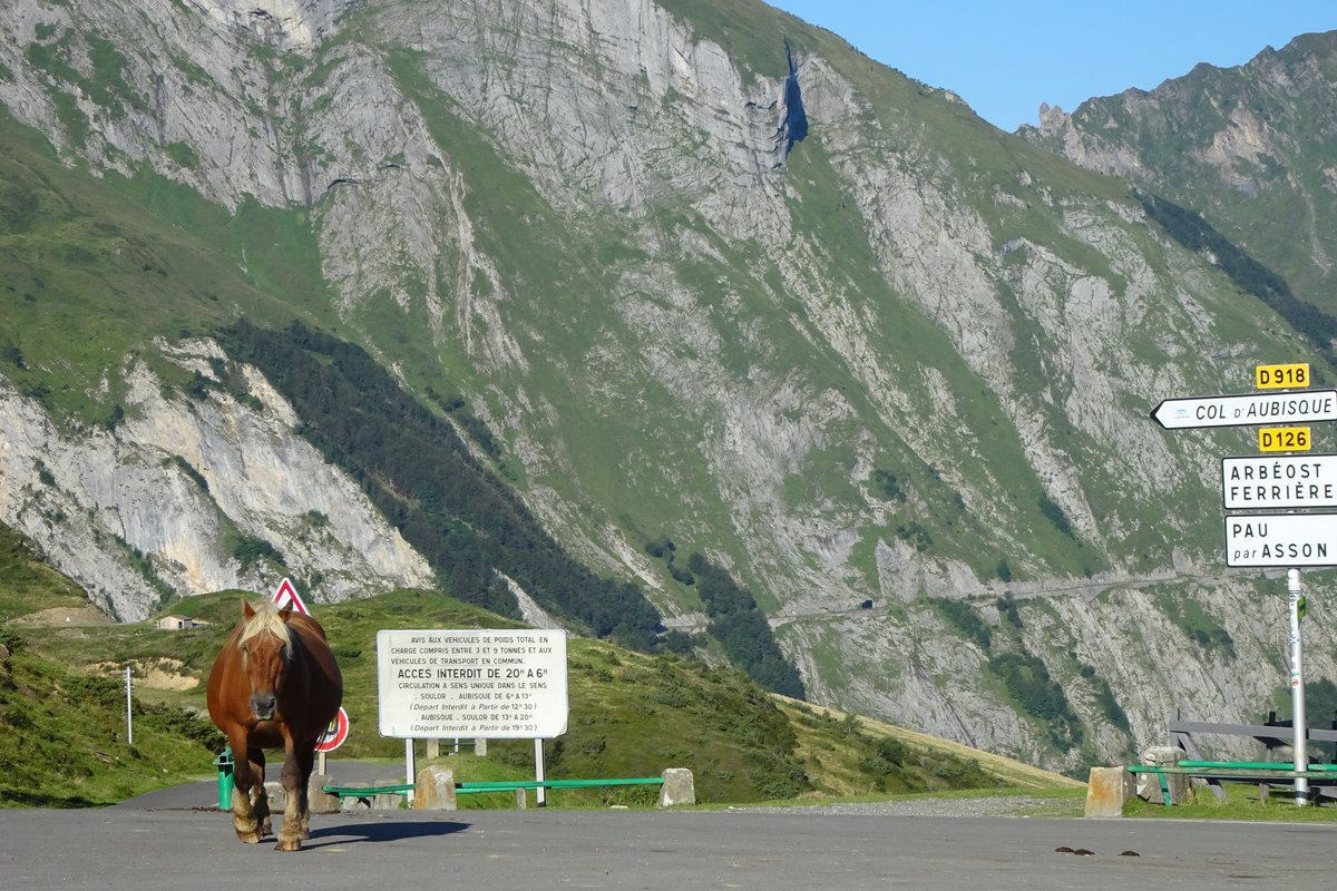
The top is an open, grassy pass with a big car park, a couple of cafés and stalls selling local cheese and honey. In winter it is a cross-country skiing area, and in summer it is pasture again, so cows, sheep and horses often stand on the road. The view west is the best part: the narrow road to the Aubisque cut into the cliffs of the Cirque du Litor. From here, the Aubisque is 10.6 km further on: a short descent into the Litor and then 7.5 km at 4.6% to the top, as described in our Col d'Aubisque guide.
The Tour de France first crossed the Soulor in 1910, the same year the race first went over the Aubisque. It is usually part of an Aubisque stage, and when the race comes from the Aubisque side the Soulor is often not counted as a separate climb, because the climb back up from the Litor is short. Since 1973 it has been a categorised climb more than a dozen times, including once as hors catégorie, the highest category, in 1982. It was a category 1 climb in 2010 and 2019, both times on stages to the Tourmalet, and most recently in 2025, on stage 12 from Auch to Hautacam, where Michael Woods was first over the top. The 2010 Tour climbed it from the Ferrières side.
Our time estimate (own calculation, rider and bike 80 kg in total, steady power, same model as our other guides, using the Altigraphs kilometre profile): about 1 hour 46 minutes at 150 watts, 1 hour 30 minutes at 180 W and 1 hour 8 minutes at 250 W. The split is the useful part. At 180 W, the steep start out of Argelès takes about 19 minutes, the nine easy kilometres through the valley take about 25 minutes, and the last 7.2 km from Arrens-Marsous take about 47 minutes. So the final third of the distance takes more than half your time. Our Aubisque guide gives about 1 h 27 for the Soulor at 180 W; that figure uses the average gradient, and the kilometre profile adds a few minutes.
Here is why the flat middle is a trap. Riding the valley at 250 W instead of 180 W saves only about 5 minutes. But if that effort means you can only hold 160 W instead of 180 W on the last 7 km, you lose almost 6 minutes there, and the last part is much more painful. Gears by the same calculation, at 180 W: on 8% you ride at about 9.5 km/h, which is 62 pedal turns per minute on 34×28 and 71 on 34×32. On the 9% kilometres near the top it is 56 on 34×28. The local tourist office's route sheet suggests gears from 39×23 to 34×23; by our calculation that means only about 40–46 turns per minute on 9% at 180 W, so most riders will be happier with a 28 or 32 at the back.
A good day plan: start easy out of Argelès, because the first three kilometres are steeper than the average suggests. Ride the valley at a pace where you can talk, and fill your bottles in Arrens-Marsous before the real climb. Then ride the last 7 km at a steady effort, without chasing riders who pass you in the first kilometre. If you feel good at the top, go on to the Aubisque: by our Aubisque guide's figures that adds about 30 minutes of climbing at 180 W, and the Litor road is the most beautiful part of the day. The top of the Soulor is about 6.5 °C colder than Argelès by the usual rule of 6.5 °C per 1,000 m, so bring a jacket for the descent.
Pro tips
- Mistake: trusting the 5.2% average: The average includes almost 10 km of easy valley road. The last 7 km from Arrens-Marsous are about 8% all the way, and that is the climb you should plan for.
- Mistake: racing the valley: Going hard through the flat villages saves only a few minutes, and you pay for it on the last 7 km. Save your effort for after Arrens-Marsous.
- Mistake: too big gears: On 8–9% a 39×23 or 34×23 forces most riders down to 40–46 pedal turns per minute. A 34×28 or 34×32 lets you spin.
- Stop for the sheepdogs: The pass is open pasture with free-roaming flocks, guarded by big white dogs (patous). The local tourist office says that if one comes towards you, stop and get off your bike until the dog has checked you.
- Watch for animals on the road: Cows, sheep and horses often stand on the road near the top, and also on the descent.
- Refill in Arrens-Marsous: There is nothing much on the last 7 km. The cafés at the top are the next stop.
- Check the road to the Aubisque: The Soulor itself is open all year, but the Litor road on to the Aubisque is closed in winter, usually from mid-November until May.
Estimate your time up Col du Soulor
By our model, a 72 kg rider on an 8 kg bike holding 216 W (3 W/kg) needs about 1:14 for the 19.5 km and 1,019 m of Col du Soulor. Enter your weight, your bike's weight and the power you can hold for about an hour of climbing.
Estimated time: 1:14:09
More about the climb time calculator ·
Steady power, no wind, no stops, and the average grade of the whole climb. Steep ramps, flat sections and descents are only evened out roughly, so irregular climbs will be less accurate. Your values are saved only in this browser.
More climbs in France
Alpe d'Huez
The 21 Hairpins — 13.8 km · 8.1% avg
Mont Ventoux
Giant of Provence — 21.8 km · 7.4% avg
Col du Tourmalet
Giant of the Pyrenees — 19.0 km · 7.4% avg
Also useful: Gearing for Mountain Climbs: Chainrings, Cassettes and Bike Setup for Alpe d'Huez, the Galibier and the Angliru
Also useful: How to Climb Long Mountain Climbs: Pacing, Effort and Fueling for Alpe d'Huez, Ventoux and the Galibier